Introduction
In order to help data users, FENGYUN satellite Data Center ( data.nsmc.org.cn) offers data users a grand new web-based GIS tool to customize FY-3A data. This tool can fulfill the users' various demands, such as data browsing, query, channel recombination, output format customizing, space information and spectral matching, etc. This article will tell you the procedure for customizing FY-3A data with this web-based GIS tool.
Step 1: Explore the FY-3A GIS earth
Open the main-page of the website and click the 'Maps' button under the title banner. Then you can see the newest FY-3A global image on this page. You can zoom in, zoom out, go to the special location, add GIS layers, contrast FY-3Aimage with basic geographic information, and export the image file.
Step 2: Search data
You can select the satellite and data-type on the left side of this page. Then click the 'search' button and you can see the data calendar which shows the data availability. Yellow blocks on this calendar means that the data is available. You can click any day and view the FY-3A image of that day.

Step 3: Order data
When you confirm the data and date that you need, click the 'Order' button to start the order procedure. First, set the special information on the left side of the page or with the red box on the image. Then click 'Next' button. Second, select the start-date and the end-date that you need, and click 'Next' button. Third, select channels of this data and set the output data format (BSQ, HDF 5.0 , and RAW).
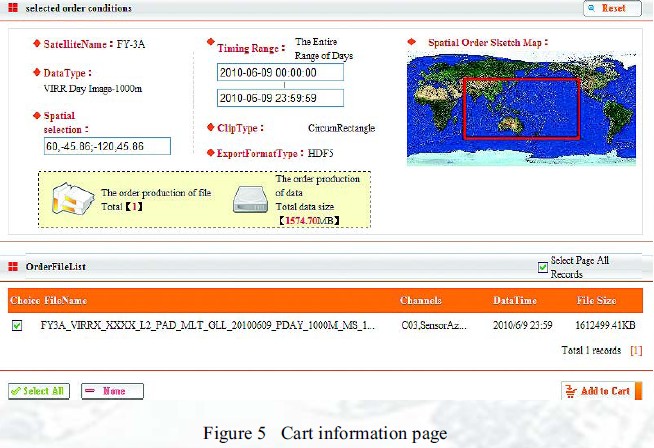
Step 4: Confirm the order
Click the 'Preview' button, and you can see the data detail which you have selected. It includes the data information, data file name, and total data size. When you confirm this order, click the 'Add to cart' button to add this data to your order cart. Then, it's time to check your order cart , confirm and submit your order.